More than 10,000 U. S. Geological Survey (USGS) stream gauges continuously measure water depth and flow in streams and rivers across the United States.
Ryan Rowland, data chief at the Utah Water Science Center, said the USGS has installed 38 new stream gauges in Utah in the past year.
“So that's about a 25% to 30% increase on our stream gaging network," said Rowland. "Right now, we're pushing about 180 stream gauges in Utah."
The USGS Utah Water Science Center director, David O’Leary, said gauges in Utah are placed at a range of waterways.
“There are gauges measuring thousands of cubic feet per second, and there are gauges measuring less than ten cubic feet per second," said O'Leary. "There's a gauge at a place called Gypsum Canyon, which is just upstream of Lake Powell. So, you're measuring the combined inflows of the Colorado River and the Green River."
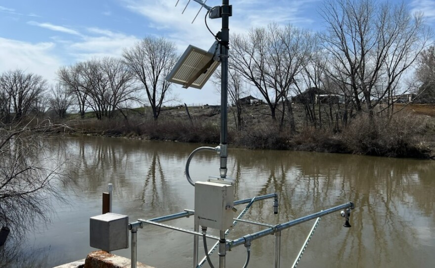
But how do stream gauges measure flow? What does a stream gauge even look like? Well, O’Leary said, you’ve probably seen one.
“A lot of times, you'll drive by a bridge, and you see one of those — it's called a Yagi antenna — kind of poking up over the edge of the bridge. And it's like, ‘Oh, that is probably a USGS stream gauge,’” said O'Leary.
Stream gauges may use a variety of methods to measure stream stage, or depth. These can include: radar sensors mounted above the surface of the water, or pressure sensors under the water.
Stream gauges also measure the velocity of the water, which is used to calculate discharge, or streamflow.
“A typical gauge is recording stage every 15 minutes and then computing a discharge value for that stage value, and then that all gets uploaded to the internet for the public to see in near real time," said Rowland.
The public can engage with stream gauge data on the National Water Dashboard website, where an interactive map shows each gauge marked with a colored dot representing whether current flow is higher, lower, or similar to historic measurements.
“The National Water Dashboard is a way to just have really good situational awareness on water resources," said Rowland.
He says stream gauges are foundational to understanding our water supply.
“Stream gauge information is what lets us know how much of the snowpack, when it melts, actually makes it into our rivers and streams and then downstream into our reservoirs," said Rowland. "So, I mean, they're just fundamental to managing water resources."
O’Leary said stream gauge information is useful not only to water managers, but also to outdoor recreationists.
“If you're going to hike the Narrows in Zion, you need to know what the flow is," O'Leary said. "If you're going to go rafting in, say, West Water Canyon, you need to know how much water is flowing there to know what the rapids are going to be like."
The goal of the stream gauge network is to collect unbiased data, O’Leary said.
“We don't manage resources, we don't set regulations," said O'Leary. "We're the science branch of the Department of the Interior, so we have no skin in the game, right? We're here to do the monitoring. … And so we have national protocols and calibration techniques to ensure that we're nationally consistent."
Rowland said the installation and upkeep of Utah’s stream gauges is a collaborative effort between local, regional, and federal agencies.
“We've been working in partnership with the Bureau of Reclamation, the Upper Colorado River Commission, Utah State University, the National Park Service, and the US Fish and Wildlife Service,” said Rowland.
“I would contend we have really good relationships with local entities who are addressing local problems, and we're really proud of that,” said O'Leary.
To learn more about how stream gauges work and how measurements are computed, visit the USGS website.