Kayakers capture water levels so low in early June that two bays were impossible to navigate as the lake continues to shrivel.
People from around the world can now get an up-close view of the Great Salt Lake’s eastern edge.
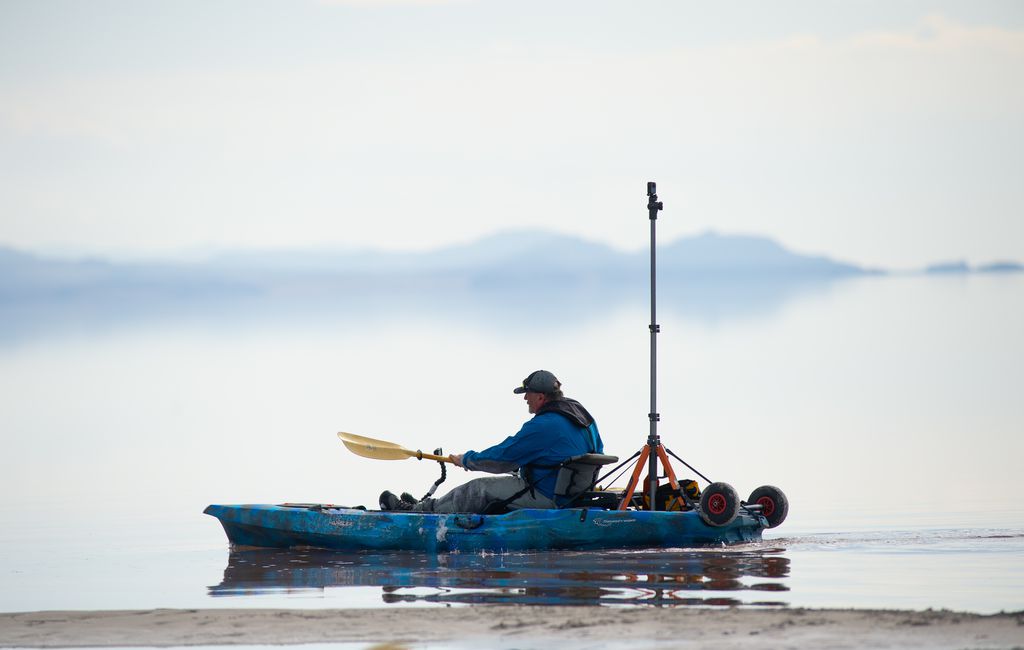
Brian Footen and Rob Crampton, founders of the startup EarthViews, spent the first few days of June paddling the lake with 360-degree cameras fixed to their kayaks, collecting street-view style imagery of the lake’s shrinking shoreline. Footen started up north, at the Spiral Jetty land art sculpture, while Crampton started down south, at Great Salt Lake State Park. The two paddled until they met at Antelope Island, creating an intimate survey of what’s left of the desiccated lake.
“It’s a really beautiful, amazing place,” Footen said. “It’s frustrating that some of that beauty is caught up in the eerie, weird [view] you get from it being a dry lakebed. That expansiveness of the landscape would normally all be underwater, right?”
Footen launched the mapping project in April in an effort to draw attention to the current “megadrought” and its toll on iconic bodies of water across the West. In addition to the Great Salt Lake, Footen plans to create street-view-style maps of Lake Powell, Lake Mead, Lake Tahoe and New Mexico’s Rio Grande.
The Great Salt Lake will undoubtedly present the most challenges. The lake’s western shore, which Footen plans to document in the fall, is remote and could be deadly under the wrong conditions. It also is much more difficult to access, with areas closed off by the Dugway Proving Ground and US Magnesium’s evaporation ponds.
Mapping the lake’s eastern edge, which is a lot closer to human civilization, presented its own setbacks. Footen had to lug his heavy boat — laden with camera equipment, instrumentation, and enough provisions for the dayslong trip — over a rocky railroad causeway bisecting the lake.
“I had to haul it over about 30 feet of boulders,” Footen said. “That made me dip into my water supply a little harder than I had thought.”
Tale of two lakes
He also got a taste of the two different ecosystems that causeway has created. The lake’s north arm is effectively cut off from any sources of fresh water. The water is so salty little life can survive, including microbialites, the ancient living rock structures that serve as a foundation for the lake’s food chain.
“That section before the causeway is really just a microbialite graveyard,” Footen said of the north arm. Crossing into the south arm, however, “the microbialites, they’re alive. They’re muddy, stinky, you can tell they’re active.”
But the north arm shows the southern end’s fate — if the Great Salt Lake continues to shrink. If the organisms that support brine flies and brine shrimp die off, that will mean no food for the millions of migrating birds that seek the Great Salt Lake as a reprieve every year. It could devastate multimillion-dollar brine shrimp harvesting and tourism industries as well.
And the ever-expanding exposed lakebed poses a significant threat to human health as it dries and turns to toxic blowing dust.
“It was interesting to look at the different types of lakebed,” said Crampton, who also works as a consultant measuring air pollution. “The farther you get from [water], the dustier it gets.”
Crampton said it was unnerving, when launching from the marina at Great Salt Lake State Park, to see rows of beached sailboats, stored and awaiting the day the lake’s water rises again — if that day ever comes.
“The last boat I saw was a Utah State rescue boat,” Crampton said, “which was parked in the south marina, and looked like it wasn’t able to get out.”
The only other vessel Crampton saw on his trek appeared to have sunk decades ago, the low water levels exposing it once again.
“The salt had just eaten all the metal,” he said. “Its aluminum was like paper, and the engine was a sponge.”
Islands no more
The lake is so low that the kayakers weren’t able to navigate Bear River Bay or Farmington Bay. They had to hug the eastern shores of Fremont and Antelope islands instead, which are islands no more.
“Sometimes you had to be hundreds of feet out just to paddle,” Crampton said. “I had to do a lot of walking. I was in 3 inches [of water].”
The kayakers collected their images from May 31 to June 5. The shoreline has continued to shift in the weeks since. On July 3, the Great Salt Lake shriveled to yet another record low. And with extreme heat taking hold of Utah this summer, the lake continues shrinking by the day.
Bonnie Baxter, a biology professor at Westminster College and director of the Great Salt Lake Institute, recently took visiting researchers to a group of microbialites near the northern tip of Antelope Island.
“They were completely dry, all of them,” Baxter said of the rock structures cemented together by microbes. “I can tell you where I was ... [looked] incredibly different from a month ago.”
The scientists were up to their knees in muck, Baxter said. The receding water had isolated portions of the lake into hyper-saline puddles. Some pools appeared bright red due to all the brine shrimp under stress. The island’s famous beaches, meanwhile, are becoming increasingly isolated from the water.
“It’s good [Footen] came out when he did,” Baxter said, “because he’ll have less access the next time.”